
The latest on a strong storm system that will impact the Twin Cities this week
A strong and complex storm system is forecast to impact the Twin Cities this coming week, bringing a wide range of impacts from rain, freezing rain, snow, and strong winds over multiple days this week. This forecast is further complicated by low confidence in the timing and arrival of precipitation, and temperature profile. We will break down the possible scenarios and the time of what to expect this coming week.
The National Weather Service out of the Twin Cities has already issued Winter Storm Watches across western and central portions of Minnesota for late Monday into Tuesday evening for 2 to 4 inches of snow, ice accumulations of up to two-tenths of an inch being possible, and wind gusts as high as 45 mph. A Winter Storm Watch will likely be issued later today (Sunday, December 11th) for the Twin Cities and western Wisconsin as confidence in precipitation type and timing hopefully increases. This system will impact the Twin Cities in a couple of rounds, which is what we will discuss next.

Based on the latest model data, it appears the first round of precipitation will work into the Twin Cities Metro by around the late afternoon to evening hours on Tuesday. In this forecast, we are favoring the later arrival of precipitation forecasted by the Euro model guidance, over earlier arrival in the GFS/NAM model guidance who have this first round arriving by Tuesday morning. On that note, confidence in the timing is low due to the spread in models, but we will be monitoring the guidance that comes out this afternoon and will provide updates on that timetable hopefully this afternoon.
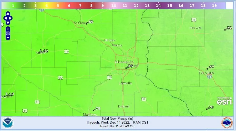
In regard to precipitation type, outside of three models keeping us around freezing, which would favor more freezing rain, the general model consensus is temperatures above freezing, which would favor mostly rain for the Twin Cities before a dry slot works over the region by late Tuesday into early Wednesday. During this initial round of precipitation, around 0.5-0.75 inches of rain is possible. The second round of precipitation and resurgence of moisture to the region returns around late Wednesday into Thursday. This second round will be a longer during snow event through about Saturday with scattered snow showers that will allow for a steady accumulation of snow through the period. Through the duration of this snow event, the profile and type of snow will also change as temperatures during this period are forecasted to significantly drop as an intense cold surge works in behind this system.
Model guidance shows temperatures around or just above freezing as the initial precipitation falls allowing for mixed precipitation and heavy wet snow to fall initially. As temperatures fall, snowfall ratios will increase and the snow is forecast to get lighter and fluffier, which could allow for snowfall totals when it is all said and done around 3-6” across the Twin Cities metro by Saturday. Some locally higher amounts can’t be ruled out.
In addition to the precipitation, winds will also be a big factor with this storm across the Twin Cities metro Tuesday-Wednesday, as this strong low pressure works across the region. Winds will be out of the south-southeast advecting both the warmer temperatures and moisture into this system from the south. Wind gusts could be in excess of 45 mph at times Tuesday and Wednesday, so if you have Christmas decorations that are at risk of blowing away it is recommended that you tie them down or take them in.
