
Excessive Heat, Severe Weather, and Flash Flooding are possible across Northern Illinois and Southern Wisconsin Today
The stage is set for a possibly active day across southern Wisconsin and northern Illinois as Heat Advisories and Excessive Heat Warnings are already in place across the area and an Enhanced Risk (3 out of 5) for severe weather from the Storm Prediction Center stretches from eastern South Dakota/Nebraska through southern Wisconsin and northern Illinois. Additionally, there is a potential for flash flooding across parts of the region with record moisture levels across the region. We will break down each threat for southern Wisconsin and northern Illinois below!
Heat
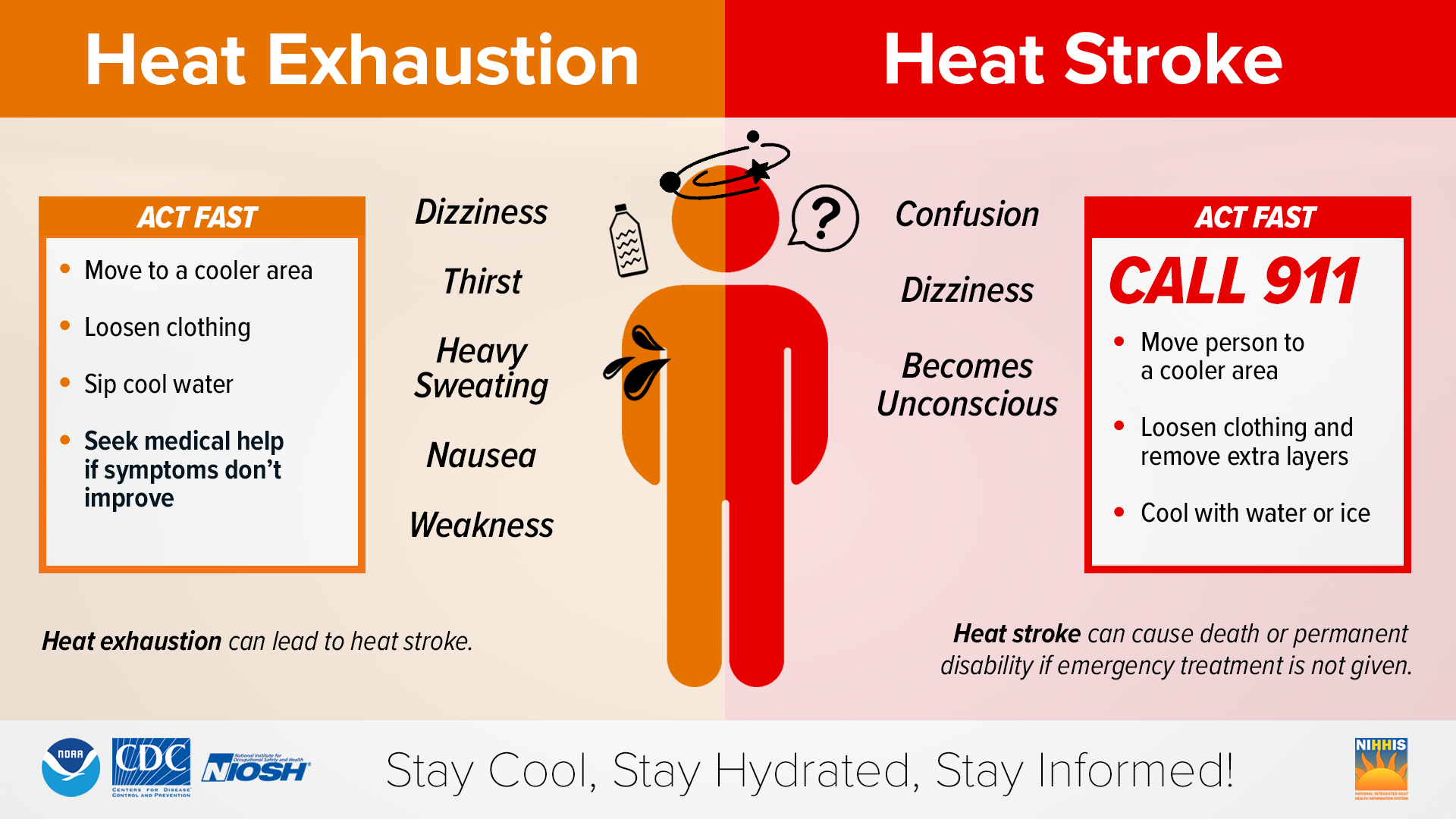
Excessive Heat Warnings and Heat Advisories already cover a large swath of the Midwest where index values of 103F to 110F in the Heat Advisories and 110F to 115F in the Excessive Heat Warnings are possible today. If the clouds clear out sooner than originally forecast, there is a chance that parts of the area currently under Heat Advisories, could be upgraded to Excessive Heat Warnings late this morning. The combination of extreme heat and humidity is expected to significantly increase the chances of heat-related illnesses today, especially for those who work outside or have outdoor activities. It is recommended to drink plenty of fluids, stay in an air-conditioned room stay out of the sun as much as possible, and check on your relatives and neighbors.
Young children and pets SHOULD NEVER BE LEFT unattended in vehicles under any circumstances. It is reported that 33 children died in hot cars in 2022 alone and 14 have died already this year alone. Don't add to the statistic. If you must work or spend time outside today, plan your most strenuous activities for early morning or late this evening (pending severe weather of course). Know the signs and symptoms of heat stroke, which we will have posted below. If you suspect someone has Heat Stroke, call 911 immediately!
Severe Weather
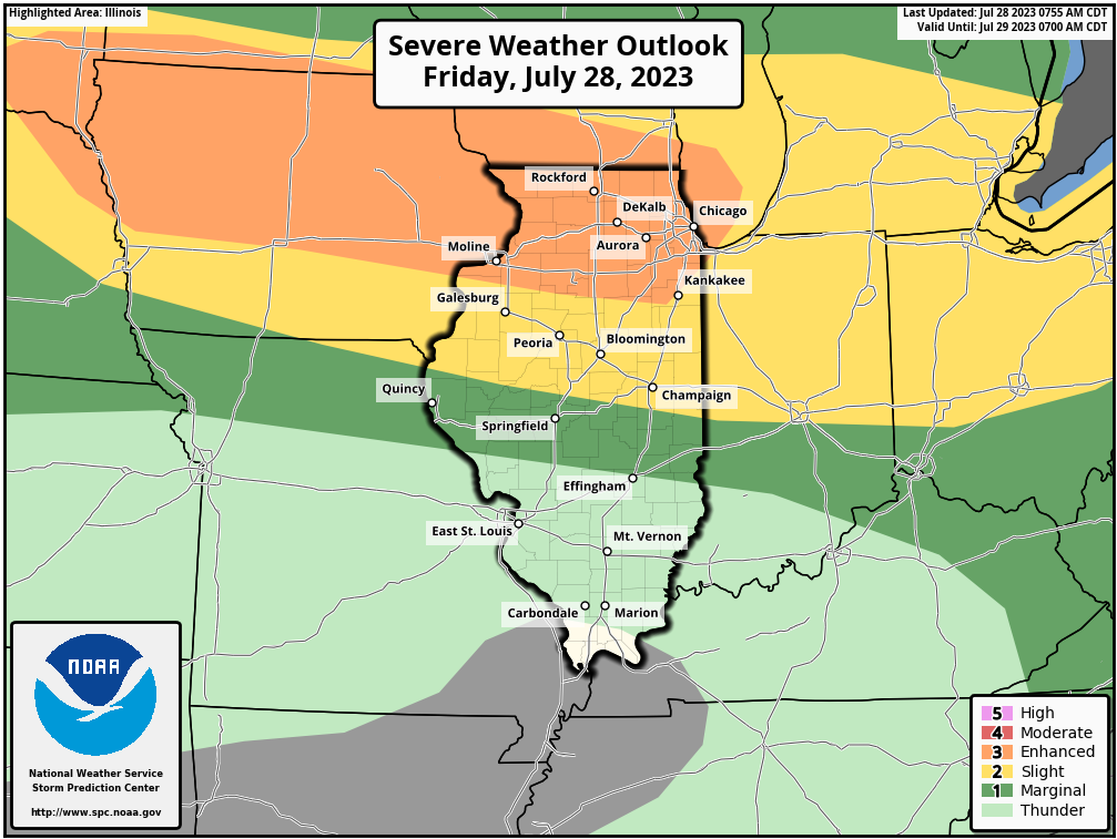
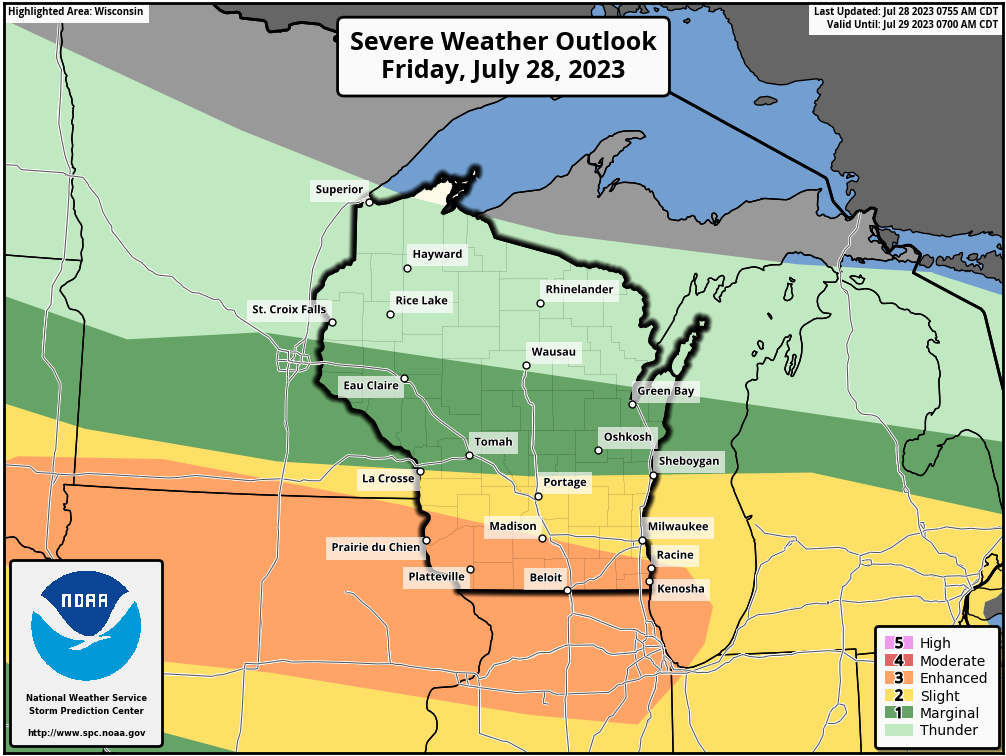
The Storm Prediction Center has a large Enhanced Risk (3 out of 5) for severe weather stretching from the Northern Plains into the Midwest in a region highlighting the region with the greatest chance for straight-line damaging winds and large hail based on the current conditions. Some shifts in the greatest threat area could occur in later updates today, though if you are within any of the Marginal Risk (1 out of 5) and Slight Risk (2 out of 5) areas, strong to severe storms will be possible. With the combination of an abundance of moisture and heat, the stage is set for robust storms if they can tap into the unstable conditions this afternoon and evening. Be sure to have multiple ways to receive severe weather alerts and be sure to be weather aware today!
The greatest threat time looks to be around and after 3 PM for southern Wisconsin and Northern Illinois, but a few models hint that an isolated shower or storm could develop as early as 1-2 PM. If any of those early cells can tap into the extremely unstable environment, they could quickly become robust severe storms and would need to be monitored. The general threat looks to end from northwest to southeast between 11 PM Friday to 1 AM Saturday.
Flooding
As we have previously mentioned, there is an abundance of moisture across the region that directly contributes to both the severe threat and the heat threat today. It also could play a role in the flash flashing threat later today as near-record precipitable water values are present in our atmosphere. Precipitable water might not be a term you are familiar with, but it is essentially the measure of how much precipitable water (liquid water) is in a vertical column of air from the surface to the top of the atmosphere. It is a parameter that is used often in combination with other parameters to estimate precipitation totals. In this instance, precipitable water values are between 2.0-2.3 inches, which tells us that if we get any training thunderstorms over certain regions today, heavy downpours are possible which could lead to flash flooding occurring in those areas.
If a Flash Flood Warning is issued for your area, heed it and remember to never drive through a flooded roadway. "Turn Around, Don't Drown!"
Follow our social media accounts for the latest breaking news updates!