
The Atmospheric River - How ongoing research could potentially be improving weather forecasting downstream from it
There is a chance you might have heard of the Atmospheric River. It is a term that has been around a while within the meteorology community but has become more popularized by the news media during inclement weather events across the West Coast of the United States and Hawaii. In this article, we will discuss what exactly the atmospheric river is, the new research that has been ongoing since 2013-2014, and how this project has continued to expand in 2022. We will also explore how this valuable research could play a very valuable role in the weather forecasts being produced for a potentially volatile winter storm that will impact the Midwest by the end of this week and the Northeast by the end of this weekend into early next week.
What is the Atmospheric River (AR)?
Atmospheric rivers are long, narrow bands in the atmosphere, usually carried along by the low-level jet, that transport water vapor [moisture] ahead of a low-pressure system. The moisture in the atmospheric river is oftentimes picked up by tropical and extratropical low-pressure systems in the Pacific Ocean. When an atmospheric river makes landfall, releases this water vapor as rain or snow. Many times, these atmospheric rivers will result in localized heavy rain and snow events that can occur anywhere from western Canada south into the southwestern United States. When the atmospheric rivers interact with a lifting mechanism, such as the mountains that stretch all along the coast of western Canada and the United States, it forces more moisture to be forced up, condense, and that condensed moisture then falls as either heavy snow or rain. Some studies have found that when you squeeze out all of the moisture from the atmospheric rivers there could be up to 25 times the amount of liquid water in that atmospheric river than there is in the Mississippi River according to Dr. Tashiana Osborne. Sounds unbelievable, but then again, atmospheric rivers are responsible for up to half of California’s annual precipitation with the heavy rain events from these atmospheric rivers causing flood damages averaging $1.1 billion annually throughout the West. - Scripps Oceanography.
These atmospheric rivers can range up to 500 miles wide, thousands of miles long, and produce wind speeds that range between 50 mph up to hurricane force. While atmospheric rivers occur all around the world, in regards to this article, we are going to focus on the atmospheric rivers that impact the United States.
What Atmospheric River research is currently being conducted?
Many have heard of the Hurricane Hunters who are a part of the 53rd Weather Reconnaissance Squadron of the Air Force 403rd Wing based out of Keesler Air Force Base, Mississippi. They are famous for performing aerial weather reconnaissance and surveillance of tropical storms and hurricanes in the Atlantic Ocean, the Caribbean Sea, the Gulf of Mexico, and the central Pacific Ocean. The data they collect is ingested into the National Hurricane Center weather models to produce more accurate forecasts for tropical systems. Something many are not aware of though is the Hurricane Hunters also perform winter storm missions off both coasts of the United States during their offseason.
One of those offseason winter missions began on January 5, 2022, which will be around 13-weeks long and is part of the Atmospheric River Reconnaissance (AR Recon) program which is led by UC San Diego’s Center for Western Weather and Water Extremes (CW3E) at the Scripps Institution of Oceanography. The basis of this AR Recon program began back in 2013-2014, with the first dropsonde missions occurring by 2016.
It’s #AtmosphericRiver season! 🌧️ This month, @CW3E_Scripps kicked off Atmospheric River Reconnaissance – the program that partners with “Hurricane Hunters” from NOAA and the U.S. Air Force Reserves to execute data-collecting missions for AR storms hitting the U.S. West Coast. pic.twitter.com/zOQGKdfXXT
— Scripps Institution of Oceanography (@Scripps_Ocean) January 12, 2022
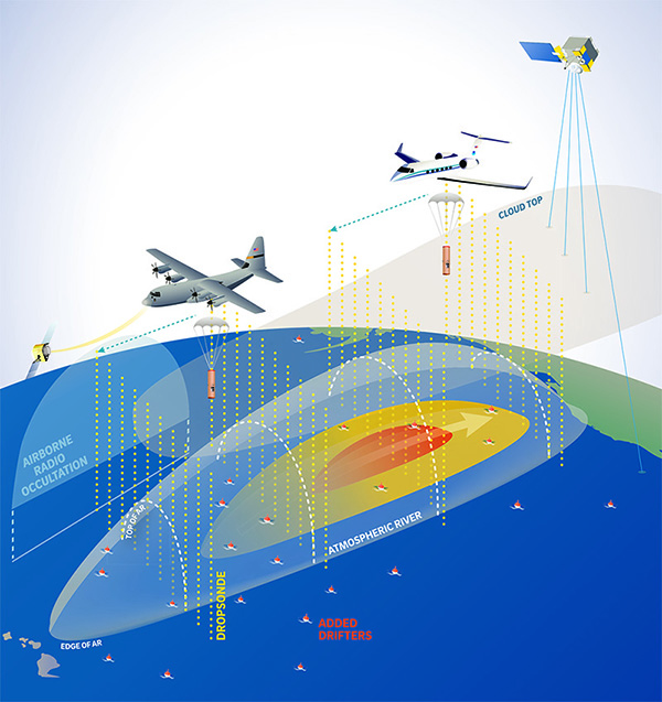
This season, the project includes the two Hurricane Hunter planes - WC-130J Super Hercules stationed at Mather Airforce base in Sacramento, CA, the NOAA Gulfstream IV-SP stationed in Hawaii, and 98 drifting buoys [50 additional buoys added onto the 48 buoys active from last season]. The graphic below is a good example of what a mission to collect data around an atmospheric river would look like with all the various parts put together that I had previously mentioned.
As previously stated, 50% of California’s annual precipitation comes from atmospheric rivers. The data collected from these missions and the research from the project are being used to help scientists better understand how to forecast atmospheric rivers in the hopes they can better mitigate the impacts on human life, including the secondary threats that come from them including flooding, drought, and wildfires which have cost billions of dollars annually.
Just back from our first #AtmosphericRiver recon mission of the 2022 winter season. Released 27 dropsondes to help the models nail down this potential AR3 event coming to the Pac NW. #WAwx #ORwx pic.twitter.com/INBF0UrfN1
— Jeremy DeHart (@JeremyDeHart53d) January 11, 2022
The above Tweet from Jeremy DeHart is from a recent mission conducted on January 10, 2022. DeHart is a meteorologist and a member of the Hurricane Hunters. In his Tweet, you will find four images. The first is the Maximum Forecast AR Scale forecast over the next 7-days for the ongoing atmospheric river out on the West Coast. The second image is from inside one of the Hurricane Hunter planes and features one of the dropsondes that they using to collect data from the planes. The 3rd and 4th images are examples of the atmospheric river in person, which look like nothing more than large clusters of clouds with the embedded threats of enhanced winds and an abundance of moisture within the clouds.
How can this research help forecast weather downstream?
Meteorologists have an array of tools they use to forecast the weather, including real-time observations and models. The weather models process billions of calculations per second around the clock. The data ingested into these models come from weather stations all across the world, weather balloon launches that occur twice a day (sometimes more during critical weather setups), and satellites. While there is a dense network of observations over land, these observations are much more sparse over the water. The data that is collected over these sparse regions usually come from planes, buoys, ships, and satellites. With the ongoing pandemic, some of those observations have decreased as not as many flights or ship routes are occurring. A vital observation we are missing over the waters is vertical observations that we would normally receive twice-a-day from weather balloon launches. This is where the Hurricane Hunters dropsonde plays a big role.
A dropsondes is a weather instrument that is dropped out of the Hurricane Hunter’s plane that falls to Earth. As it falls, it is collecting a vertical profile of the atmosphere including pressure, temperature, and humidity similar to a weather balloon. This data is then ingested into the models for a more accurate model run and better forecasts. This is same data collection is also occurring within the strong storm systems in the Pacific Ocean that eventually impact the Western United States and work their way east across the country. The influx of data we are getting from the Hurricane Hunter dropsondes and the additional weather buoys in the Pacific Ocean is allowing for more real-time data to be ingested into our weather models which they are using to create more accurate forecasts. This additional data has been vital as meteorologists are forecasting an impactful system that will track across the Midwest Friday into Saturday, across the Tennesse Valley Saturday into Sunday, and into the Northeast Sunday into early next week.
25 more drops today to feed the models. A bonus of flying these EPAC missions is the potential downstream impact. In addition to the landfalling AR in the PNW, the last 3 days of recon are helping to initialize this weekend's developing winter storm over the eastern U.S. https://t.co/MGzFUAuZwf pic.twitter.com/29vbRadrrD
— Jeremy DeHart (@JeremyDeHart53d) January 13, 2022
Sources:
Center for Western Weather and Water Extremes
UC San Diego - Scripps Institution of Oceanography | “Atmospheric River Storm Observations over the Pacific Ocean to Expand this Winter” by Steven Koppes
Sonoma Water