
What a top ten heaviest snowfall season means for Twin Cities Spring flooding outlook
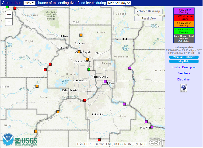
Greater than 50% chance of exceeding river flood levels during March, April, and May
National Weather Service - Twin Cities
ST PAUL, MINNESOTA - With officially 80.3 inches of snow on the season at the Minneapolis-St Paul International Airport, this season slides into the #8 spot of heaviest seasonal snowfalls. The record heaviest seasonal snowfall was set back in 1983-84 with 98.6 inches of snow. The Twin Cities only need another 4.6 inches to crack the top 5 heaviest seasonal snowfalls, which could be possible based on the latest model guidance for the end of this week.
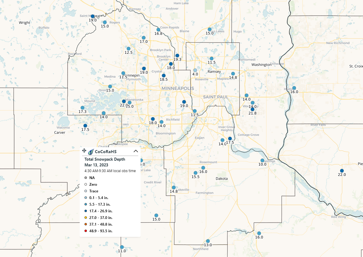
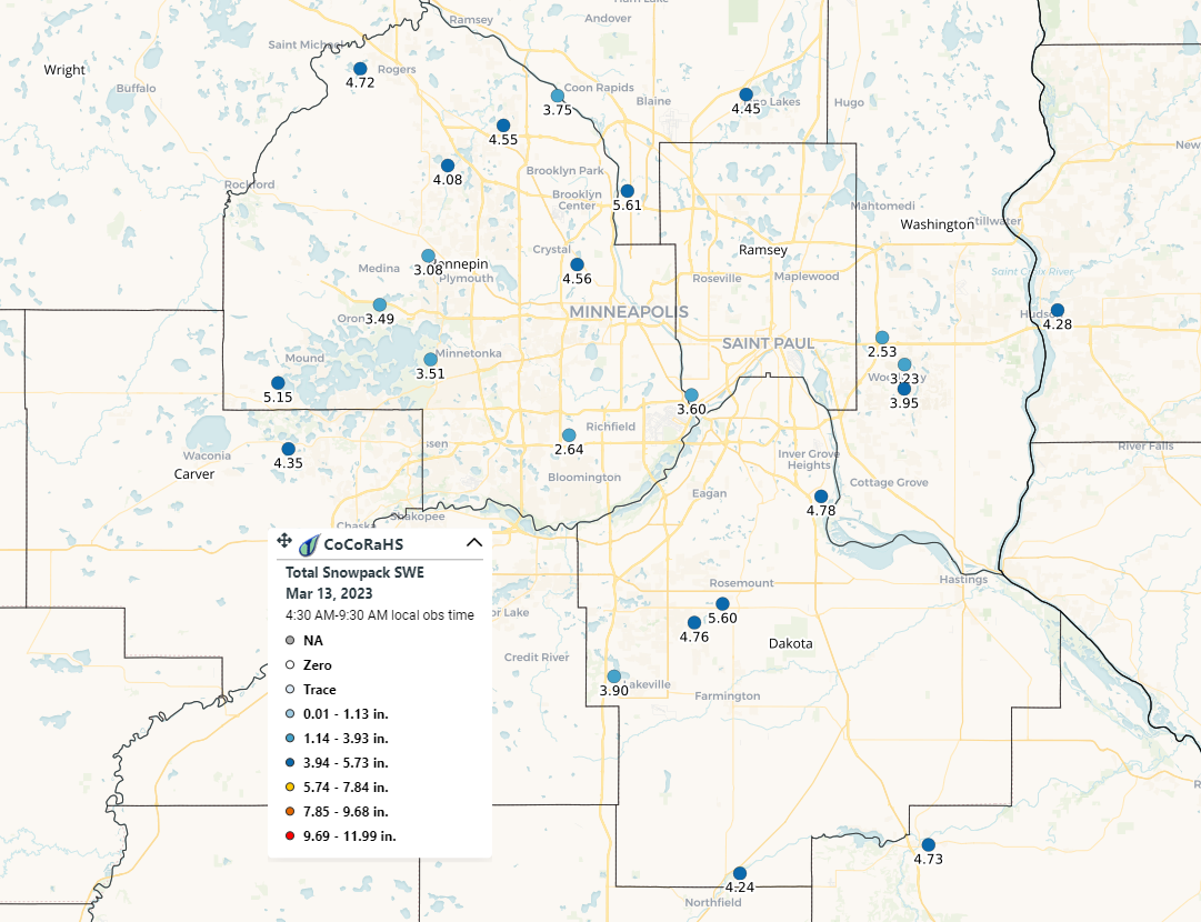
While we have seen around 80.3 inches of snow for the season, total snowfall depth across the Twin Cities ranges around 11.0 to 22.0 inches. If you were to take a column of snow from the snowpack and melt it, you would get a value known as the Snow Water Equivalent (SWE). The SWE value for the snowpack we have on the ground right now ranges between 2.5 to 5.6 inches of liquid precipitation for that column of snow. In perspective, the average monthly total precipitation between 2000-2023 is 2.6 inches. That is equivalent to a month's worth of precipitation, and this is before any possible additional accumulation that could occur. In fact, according to the National Weather Service in the Twin Cities, the SWE for this year compared to normal ranks in the 90th percentile, which means over the last 70 years, there have only been about 5 to 10 years where there has been this much water within the snowpack.
Now this snowpack will melt, that is a given as we get further into Spring, and the average daily temperature continues to increase along with the amount of time we see the sun each day. The risk of flooding is a little more complex since many factors go into that risk. Some of those factors include soil moisture, drought, frost depth, ice coverage on rivers, water levels of lakes, ponds, and other water retention areas, and ice jams.
Going into the Fall, the entire Twin Cities region fell under moderate to extreme drought following back-to-back years of low snowfall and limited summer rainfall. Fast forward to the latest U.S. Drought Monitor map, released on March 9th. The entire Twin Cities region has reduced its drought category to abnormally dry. Some parts of the region even completely exiting the drought returning to normal or just above normal across the far northern Twin Cities. While coming out of a drought is great news, this will impact soil moisture across parts of the region, which could play a role in an increased flood potential. Soil moisture, or soil water, is the total amount of water in the land, excluding rivers, lakes, or groundwater. When the Twin Cities was in drought, soil moisture was below average, which means the soil could hold more water if it were a slow and steady rain. Slow and steady rains gave the precipitation a chance to soak into the soil compared to heavy rain, where it might not permeate well and would run off if the ground was too dry and hard. As parts of the region return close to normal, the soil moisture increases. If the soil moisture is at or above average, the soil has no room to store the snowpack melt. That water will instead puddle (flood) or runoff.
Another factor that plays a role in soil moisture and water infiltration into the soil is frost depth. When the ground is frozen, water cannot filter through it until it thaws. So often, this liquid will just run off. While many were unhappy to see the early snowfall this past fall, it could benefit the Twin Cities region this Spring when it comes to flooding since snow is an insulator. The early snowpack helped to prevent the cold temperatures from going too deep and kept our frost depth rather shallow this year. This means more snow melt can soak into the soil and not run off like in previous years.
Drought also played a role in the river, lake, pond, and wetland levels, causing many of them below normal during winter. This means many of these bodies of water will have more room to store snow melt before they begin to crest their banks, and the extra water is then sent as runoff to the rivers.
So with all this in mind, what are the chances of seeing flooding across the Twin Cities this Spring based on all the factors mentioned above? The National Weather Service in the Twin Cities has a Long Range model that can use the most recent weather observations to calculate the risk of flooding across a section of river based on the nearest rivet gauge. The latest long-range flood probability forecast is based on the weather conditions collected on March 6th for March, April, and May. From this data, which you can see in the graph below, there is a 61% chance of seeing major flooding along the Mississippi River near the Roberts St Bridge in St Paul, Minnesota, between March 13th to June 11th. Additionally, there is just about an 80% chance of moderate flooding and around 90% that at least minor flooding will occur.
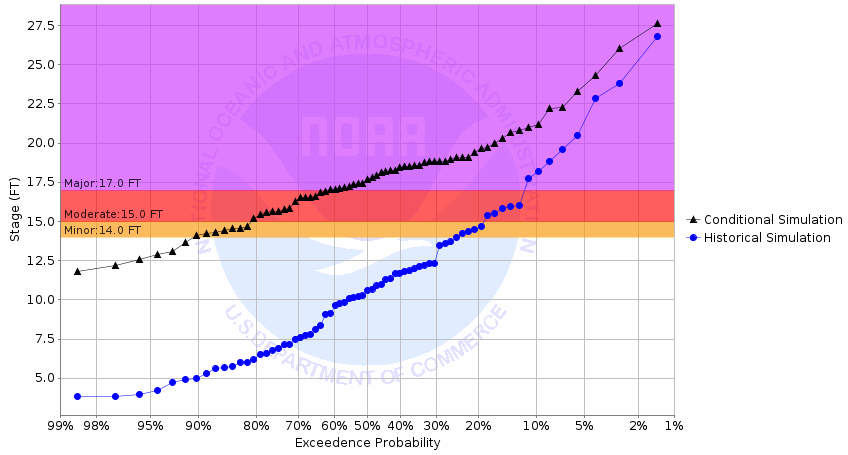
Chance of Exceeding River Stage at Mississippi River at St Paul - Roberts St Brdg (STPM5)
Photo by National Weather Service - Twin Cities
For this location, the major flood stage begins around 17 feet, with Harriet Island beginning to become submerged at 17.5 feet, according to National Weather Service data. Passed on the latest forecast, a crest of around 18 feet is possible, which would cause Warner Road to become impassable due to high water. Moderate flood stage, which again was around an 80% likelihood, begins around 15 feet of water. This would likely result in parts of the Lilydale Park area being flooded with impacts to the park beginning around 14 feet. Water St would likely be partially submerged as water is forecast to encroach the road by 13.3 feet.
We will have to see what impacts any additional snowfall will have on this forecast. Still, based on the latest model guidance and conditions, there does appear to be a good chance that parts of the St. Paul metropolitan area could see impacts as we begin to melt off this snowpack. Low-lying areas along the rivers in the area might want to begin planning for the chance they could see flooding extend into their backyards this Spring. For more on Flood Safety, you can check out the link below.
Severe Weather Awareness - Flooding Safety