
June 13th Severe Weather Recap - Tornado and Derecho were Confirmed
UPDATED: Illinois section of the story with final report from the NWS Chicago and the derecho section was updated at 1 AM on June 15th.
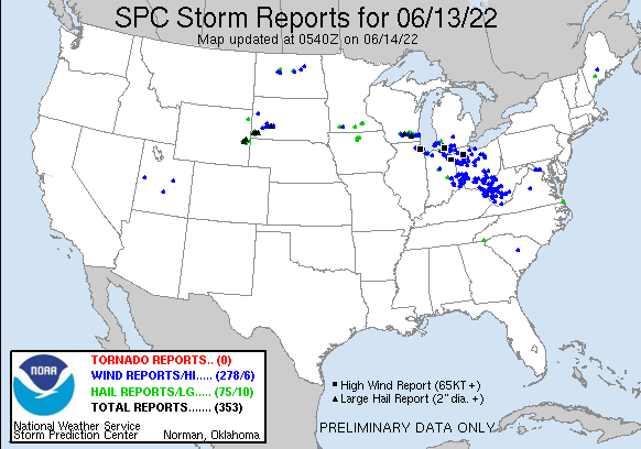
Widespread severe weather wreaked havoc across the Midwest this afternoon and evening and continues to as of 11 PM on June 13, 2022 with a line of severe storms working across central Ohio. From Madison and Milwaukee, Wisconsin to Chicago, widespread wind damage and flooding are being reported along with a large swath of reports from Madison to Milwaukee of large hail ranging between 1.00 to 2.00 inches in diameter. Below you will find a recap of the events that unfolded today with additional updates to come as the National Weather Service office conduct several surveys into the damage that occurred all across the region today.
Southern Wisconsin
Following an early round of showers and storms across the region, additional storms began to develop northwest of Madison, Wisconsin around 1 PM. These storms quickly became robust severe storms with the National Weather Service in Milwaukee issuing severe thunderstorm warnings soon after to the northwest of Madison for 50+ mph wind gusts and 1.00” hail. Just after 2:15 PM, severe thunderstorm warnings were then issued for the northern suburbs of Madison. These storms continue to strengthen as they worked off to the east-southeast reaching downtown Madison around 3 PM. These storms produced golf ball-sized hail, wind gusts around 70 mph, and very heavy rain which left widespread wind damage reports and flash flooding across the city of Madison and surrounding areas. In the below video, you will find a collection of clips from Madison and Johnson Creek of golf ball-sized hail, followed by two clips of large tree damage from around the city of Madison.
At the peak, We Energies was reporting over 45,000 customers without power across southern Wisconsin. Additionally, Madison Gas and Electric (MGE) was reporting more than 230 separate incidents and about 21, 000 customers who were without power across the city of Madison at 5 PM. MGE reports that as of 9:30 PM, two-thirds of impacted customers have had their power restored. At the writing of this article, around 11 PM on June 113th, We Energies was reporting just under 30,000 customers still without power.
Chicago/Northeast Illinois
FINAL UPDATE: The National Weather Service in Chicago concluded that a large swath of severe straight-line winds occurred across the Chicago metro on June 13, 2022, with wind speeds as high as 90 to 95 MPH across West-Central Cook County. Those are winds equivalent to an EF-1 tornado. The worst of the damage was found to be in Streamwood, Schaumburg, Roselle, Bellwood, Westchester, Riverside, and Brookfield. Notable structural damage was reported at a couple of apartment complexes where roofs were peeled off the buildings in both Bellwood and Westchester. Two injuries were also reported at the Bellwood apartment complex.

Additionally, the National Weather Service in Chicago did confirm one tornado that occurred in Schaumburg-Roselle. It was rated an EF-0 tornado with sustained winds of 80 MPH. The tornado track was 2.2 miles and the tornado was about 25 yards wide. The tornado track was on the far east side of a large swath of 75+ MPH winds that were linked to the rear flank downdraft that wrapped around the tornadic storm. These winds were tied to the flipping of a small plane at the Schaumburg Regional Airport and also additional widespread tree damage across the south side of Schaumburg and into Roselle.

For a full recap of these events from the National Weather Service in Chicago, including a look at the storm reports and rainfall totals, you can visit the following link: June 13, 2022: Supercell Storm Brings a Swath of Severe Wind Damage to Chicago Metro & One Tornado (Updated 7 PM)
UPDATE: The National Weather Service in Chicago reports a strong supercell tracked over 100 miles from northeast Illinois to northwest Indiana between 5:30-8:30 PM on Monday, June 13. This supercell caused a wide swath of wind damage along its path and also produced quarter-sized hail. They are reporting the majority of the straight line wind damage from this storm occurred in the area of Schaumburg and Brookfield, with pockets of significant damage also being reported in Roselle, Bellwood, and Westchester. They are reporting at least a hundred trees were downed from this storm and many more were damaged, which resulted in widespread power outages across the Chicagoland and surrounding suburbs. Some structural damage is also being reported between small planes at the Schaumburg Airport, and a roof was partially blown off an apartment building in Bellwood. Two injuries are being reported from the apartment building, but the extent of these injuries is not known at this time. Crews are continuing to survey the damage this afternoon, to determine if a few brief tornadoes occurred or not. More details will be made available in regards to that at a later point. The National Weather Service also shared that the supercell that worked across the Chicago metro on Monday, June 13th, was around 60,000 feet tall!
——————————————————————————————————————
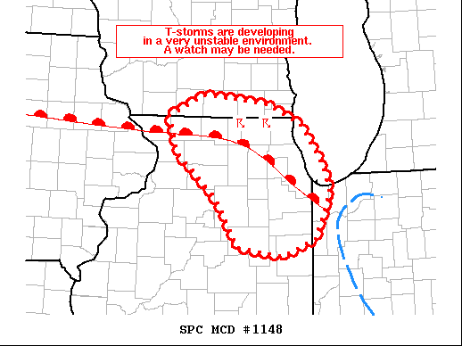
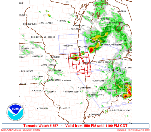
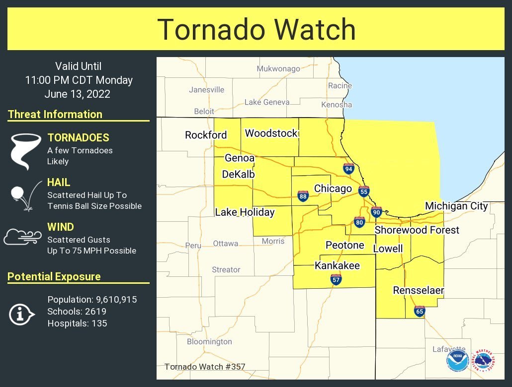
ORIGINAL STORY: Just after 5:30 PM the Storm Prediction Center out of Norman, Oklahoma issued a Mesoscale Discussion talking about the quickly increasing threat of severe storms and the high possibility of a Tornado Watch being issued for northern Illinois as storms had begun to develop along a warm front that was draped over the region. A highly unstable environment was in place over the region with 4000-5000 J/kg of CAPE available to support quickly developing and robust storms. By 5:52 PM a Tornado Watch was issued for northeast Illinois, including the Chicago area as several supercells were now developing along the warm front just to the north. Wind gusts of 75+ mph and very large hail up to 2.5 inches were possible with these storms.
By 5:55 PM a Tornado Warning was issued for Elgin, Streamwood, and Hanover Park, Illinois until 6:45 PM for a radar-indicated tornado. This supercell would eventually continue to track from northern Kane and McHenry Counties southeast through the Chicago metro and into northwest Indiana. Along the way, this storm would warrant the issuance of several more tornado warnings which also resulted in the evacuation of Wrigley Field and a delayed start to the baseball game. Check out the video at the top of the page for a taste of what the eerie tornado sirens sound like from the Windy City!
This storm would go on to produce several damaging wind reports including a measured wind gust of 84 MPH at the O’hare International Airport and a 74 MPH wind gust from Navy Pier. This storm also produced heavy rain across the city that resulted in a few reports of flash flooding and also a few large hail reports. At this time there are no confirmed tornado reports, but the National Weather Service will be out surveying damage reports in two areas on Tuesday for possible tornado damage. Those two areas are the Streamwood/Schaumburg/Roselle and Westchester/Bellwood/Maywood areas.
On the power outage side of things, ComEd is reporting 918 outages as of 1:22 AM on Tuesday, June 14th which is impacting over 42,980 customers. The majority of those are coming from Cook, Kane, and DuPage Counties.
Was this a Derecho?
UPDATE: The Storm Prediction Center in collaboration with the local National Weather Service offices in Indiana and Ohio has confirmed that the storms on June 13th meet the criteria of a derecho for the swath of damage that occurred from Northern Indiana/Southwestern Michigan through at least Ohio. The section of storms from Madison to Milwaukee is not being considered because they tracked over the lake and weakened, then redeveloped later in the day. Then the stretch of damage from the Chicago metro was not included, as it was part of a supercell.
Significant damage is being reported from the Fort Wayne, Indiana area as the strongest winds ever recorded at the Fort Wayne International Airport with a wind gust of 98 MPH. A large swath of 50 to 75 MPH was measured all across the region.

——————————————————————————————————————
ORIGINAL STORY: Another thing that will need to be determined over the coming days is whether or not this will be considered a derecho. By definition, a derecho is a widespread, long-lived wind storm that is associated with a band of rapidly moving showers or thunderstorms. The wind swath must extend more than 240 miles and include wind gusts reports of at least 58 mph or greater along most of its length.
If we take the initial cluster of storms that started around the Madison, Wisconsin area and take the track of those storms off to the southeast, the 240 mark would roughly be around south-southeast of Battle Creek, Michigan. For the most part, there appear to be damage reports (blue markers on the map below) that stretch almost that entire way. Weather stations and observations over Lake Michigan can be a little sparse. The damage reports continue off to the southeast into West Virginia which is more than double the required distance. The big question now will be, was the 58 mph wind requirement met or not.
As more reports come in from the storms and as the National Weather Service is able to get out and survey the damage, I am sure will be see more confirmed information come out from the various office over the next day or two. We will continue to update this story as more information is made available.