
Confirmed Tornado in Beloit, Wisconsin - May 25, 2022
5 PM Update - May 26th - The National Weather Service (NWS) conducted a damage survey on the Beloit, Wisconsin tornado and it was rated an EF-0 with peaks winds of around 75 mph and a path length of around 3.5 miles long. The NWS provided the following summary of the storm and tornado:
Showers and thunderstorms streamed into southern Wisconsin ahead of and along a warm front during the evening of Wednesday, May 25, 2022. There was just enough turning of the winds (shear) and instability for a few storms to rotate. One storm strengthened and started rotating over Winnebago County in north central Illinois and tracked into southwest Rock County at 6:37 pm. The storm produced a tornado as it tracked northwest of Beloit.
Tornado damage was observed along a narrow path on the northwest side of the Town of Beloit. The path crossed Hwy 213 near W Creedy Rd. Mostly sheds and large branches were picked up and lofted a few yards downstream. Video evidence of a tornado was provided as well.

For more information you can go to the follow link from the NWS Milwaukee: https://www.weather.gov/mkx/2022May25_BeloitTornado?fbclid=IwAR0XYtyEo3BTYpHcrkUYBsnVETVvH4aj143u1xpMzBBc6T2bAsLh8Ih_av4
10:00 PM Update - May 25th: The National Weather Service has confirmed a tornado did occur this evening via video sent in from the public. The tornado occurred about 6 miles northwest of Beloit, Wisconsin, and about 3.3 miles southwest of Afton, Wisconsin near the intersection of S Paddock Rd and W Finley Rd in Beloit. We are gathering more information in regards to this story and will be updating this article with further updates.
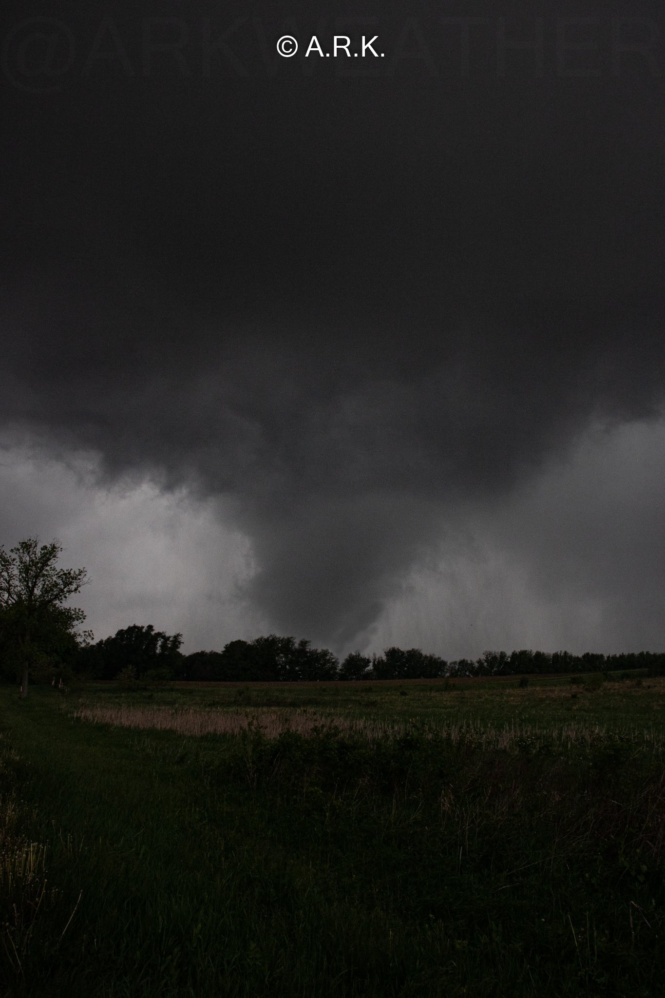
A.R.K. crew reports seeing the tornado on the ground just after 6:53 PM on Wednesday, May 25th as they were traveling on W Finley Rd which is located about 6.5 miles northwest of Beloit, Wisconsin and about 3.5 miles southwest of Afton, Wisconsin. They captured some photos, which you can see pictured below, and then watched as the tornado lifted over the field to the north of W Finley Rd.
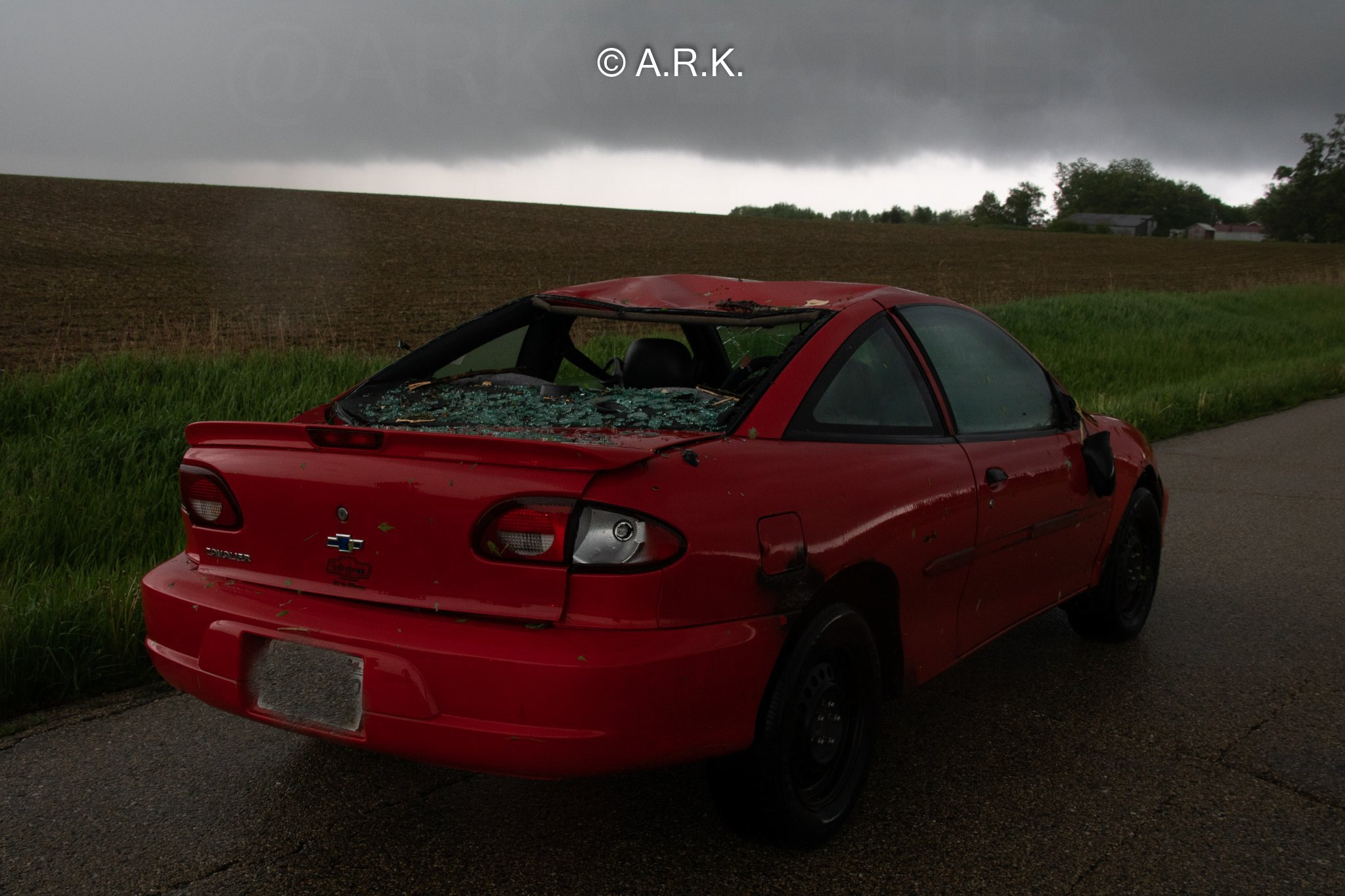
Not too long after, they said a man drove up to them in a red car that was wrecked, who had stated that he ended up getting caught up in the tornado and could not escape. The rear window of his car was blown out, the roof caved in, and his front windshield was badly cracked. The man was visibly shaken, but not injured.
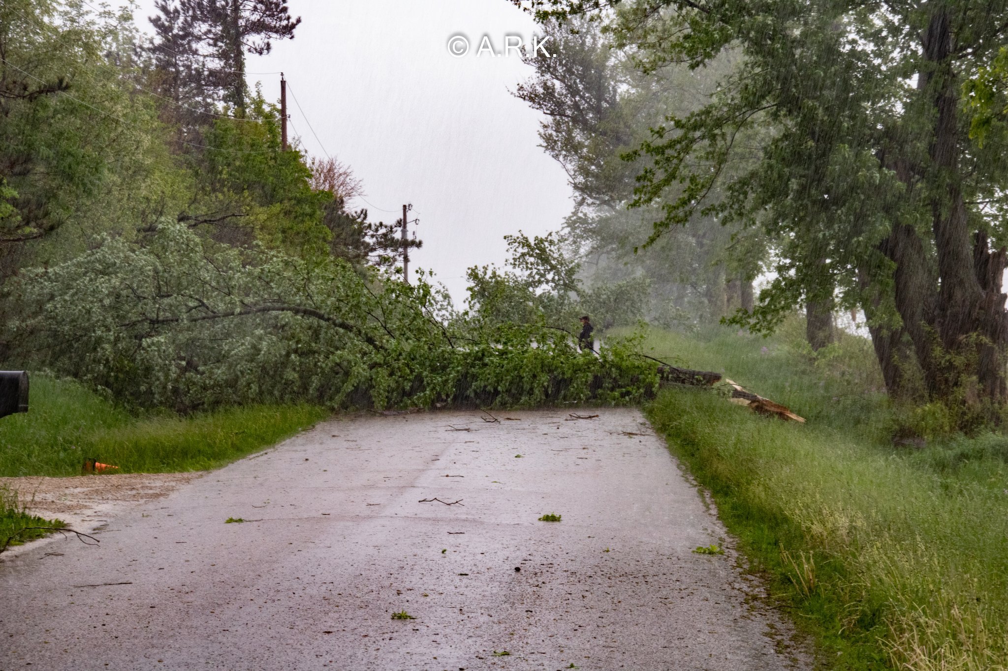
Additionally, the A.R.K. crew reported seeing several large trees and limbs down blocking Finley Rd, and also a trampoline that was partially on the roof of a home. Below you will find a few photographs that they gave us permission to share. The photos include one image of the tornado and one image of the car the gentleman was in that was hit by the tornado.
The following images were provided to us from A.R.K. - Atmospheric Research & Knowledge.
ORIGINAL STORY: Around 7 PM on May 25, 2022, the National Weather Service in Chicago-Romeoville, Illinois issued a radar indicated tornado warning for Winnebago and northern Ogle Counties in Illinois with the National Weather Service in Milwaukee-Sullivan issuing an extended tornado warning for Rock county in Wisconsin. At this time there has not been any confirmation that a tornado had touched down or of any damage associated directly with a possible tornado yet.
Northern Illinois
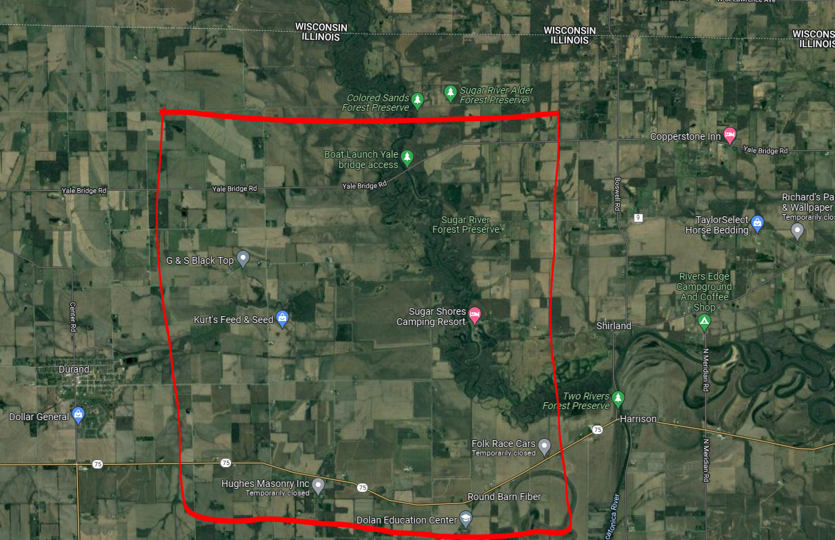
Taking a closer look at archived radar data, a video of this can be found at the top of this article, you can see a tightening couplet just north of County Road 75 (Freeport Rd), between Wheeler Rd and Shirland, IL. The possible tornado appears to have tracked close to if not over the Sugar Shores Camping Resort or Sugar River Forest Preserve Campground. I have put a square roughly around the area of interest in the image below.
Southern Wisconsin
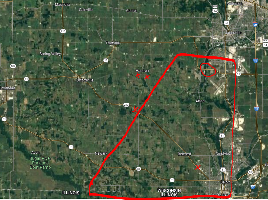
Once in Wisconsin, archived radar data shows that the storm that promoted the initial tornado warning looks to have strengthened once again, with another tightening couplet just to the east-southeast of the Town of Newark along County Road 81 as the storm worked off to the northeast. The couplet reached its second point of peak intensity in the area of W Beloit Newark Rd and S Smythe School Rd which is just east of Newark, WI. To the northeast of that, there appear to be some unconfirmed damage reports. There is also one unconfirmed report of a funnel cloud just north of the Janesville, WI airport [visible in the map below where the circle is].
There are some isolated reports of some minor damage in the area of WI-213 and West Spring Creek Road in the outskirts of Beloit, Wisconsin, but this damage appears to be east of where any couplet might have been. Likely some straight-line wind damage, but we will continue to look into that. We will continue to update this article as we learn more. The red X on the map people designates rough locations of storm damage reports. the red polygon highlighting the area of interest from the storms.
County Wide Tornado Sirens
We saw several people wondering why the tornado sirens were going off all across the county when there was no ongoing tornado in their particular area, so we wanted to touch on that quickly. I can not confirm if this is statewide or not, but for the most part across Southern Wisconsin and Northern Illinois, the siren system is a county-wide system. This means, that anytime the tornado sirens have activated the tornado sirens across the entire county are activated altogether even if the threat is only for a small section of the county.
In some counties or cities, for example in the Oklahoma City area, their siren system is set p in quadrants that they are able to set off individually across the county based on the threat. If it an isolated to just the northern portion of the county, only the sirens across the northern portion of the county will go off.